GeoID app good for
This is by far the best smartphone application for geological measurements to date. Very powerful and incredibly easy to use. Forget your heavy and expensive compass-clinometer from the previous century!
GeoID seems to be another name for the Smart Compass-Clinometer application presented and discussed in the article by Sangho Lee, Jangwon Suh and Hyeong-Dong Park published in Computers & Geosciences (2013, vol. 61, p. 32-42).
Powerfull tool to geologist. This App help so much in the geologist jobs.
A very professional app!! But, if anyhow possible, please switch the position of the "Record" area from the lower right to the upper right.
If you handle the clinometer with one hand only (right hand side) the tip of your pointing finger is located there also. Then the app will be completely perfect!
Stereonet = Rock mechanic, rock and soil, slope stability wow!! Very useful ! Useful app for rock mechanics and rock engineering !!!
I continue to use this wonderful App and every time I use it, I realize how it’s done well. May I suggest an integration. Why don’t you introduce the possibility of making the characterization of rock masses through engieneering classifications (for example Bieniawski, GSI)? Paolo Zaffiro Italy
Some bad moments
How can I do to have running the compass to record the direction of planes and lines?
I think its worth the money. Have yet to really test in field (want to do a Brunton vs smartphone test) but it worked well on some homemade structures I made. Many great options and very easy to use. Recommended for structural geologists!
What I liked:
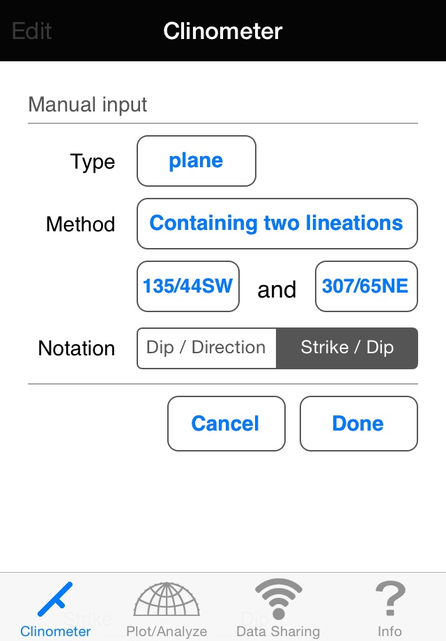
-Lets you use your iPhone as a compass to measure strike/dip, trend/plunge by using magnetometer.
-Can enter data manually or using the magnetometer.
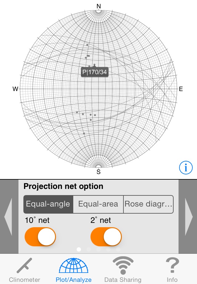
-Plots circles (planes), and points (lines) on a stereonet (10 or 2 degree option)
-Can compare stereonet to current plane.
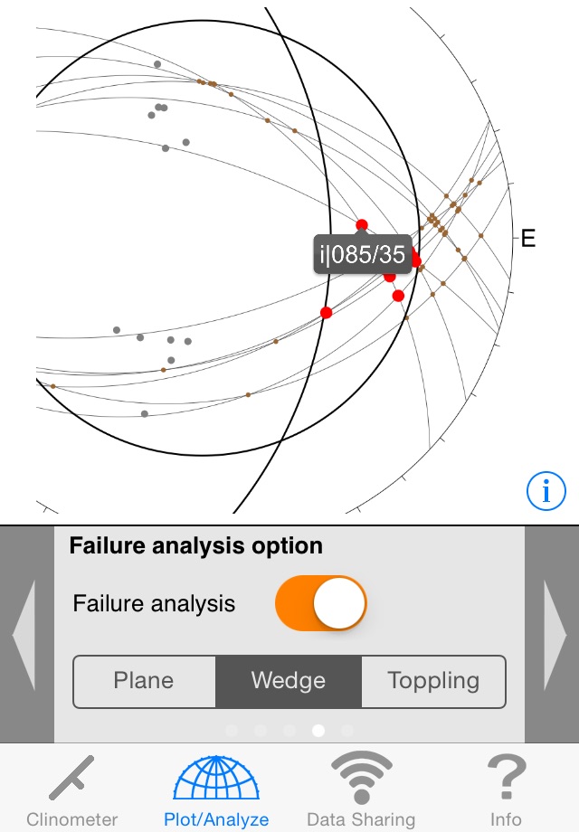
-Can highlight intersections of planes on steronet.
-Many options to single out data on stereonet all quickly accessible.
-Failure Analysis
-Ability to export projects via bluetooth, email as text
-Ability to store multiple projects
-Very professional look (Looks like a tool and not a toy, if that matters to you)
What I didnt like:
-Wont export photo of stereonet (but you can always use the phones Print Screen function by simultaneously holding down "Hold" and the "Home" button. It says you can in the description, but I cant seem to find the option to send anything but a text file in either text or scv (comma separated values).
-Kind of expensive. Give us geologists a break. We need to be saving our money for beer!
[updated comments originally made for v. 1.4] GeoID is the first iPad optimized application to allow routine collection of plane and line orientations combined with making simple stereonet plots. Data can be exported in a variety of formats (CSV, TXT) and by a variety of means (Bluetooth, e-mail, iTunes). Given that the data are georeferenced from the iPads location services (including a scalable Google Satellite view) this could be quite useful. It also does simple failure analysis.
As a geology professor working with undergraduate and graduate students (and other professionals) doing mapping at all levels, GeoID is the first iPad app that might replace routine use of a Brunton or similar compass. Having just begun to use this app, I have yet to closely compare the results from the iPad with independent measurements, however the precision (reproducibility) seems to be within a few degrees when measured on the same plane in multiple places and with multiple orientations of the iPad. (Measuring planes is nominally independent of rotation of the iPad within the plane. Azimuth becomes noisy near horizontal. Linear elements are measured as lines perpendicular to the plane of the device. It would be better if these could be determined say along the long-axis and toward the top of the device. [A modification was made in v 1.5, but still doesnt offer this as the result.])
At this time, I rate the app with 4 stars based on its:
(1) currently unique capabilities for the iPad to collect line and plane orientations,
(2) ease of use including the simple export options,
(3) choice of display types including stereonets and rose diagrams,
(4) ability to acquire multiple data sets (though not to plot them together), and
(5) potential for becoming something quite powerful.
As it stands, GeoID will likely supplement but not displace routine Brunton use, nor is it a substitute for recording information on a map. To become more generally useful, it would benefit from several modifications. Major improvements would include:
(1) allow annotating individual data, rather than just data sets – in v 1.5 this may be possible on an iPhone (I use an iPad),
(2) plotting different data sets jointly on diagrams and maps,
(3) plot orientations in map view (with or without imagery),
(4) link to photos taken with the iPad (as some other iPhone strike/dip apps allow)
Desirable additions would include
(1) cache map images (and/or import georeferenced images)
(2) provide location data as UTM in addition to Lat-Lon
(3) keep and plot GPS tracks
(4) allow KML/KMZ export with appropriate symbols
In the long run, a tool like this would be most useful if it were incorporated into a GIS package.
*** On the downside – and one of the reasons for this extensive set of comments – is the lack of functioning English language support. This is a major problem and nearly rated a downgrade to three starts, as I would like to communicate directly with the programmers.
MDBartons review is right on. The lack of English support is a major issue for me.
As a graduate student in Geology, the data I collect is in various formats: quad (N30W, 20NE), azimuth (330, 20) and direction/dip (060,20). While the app appears to display data in different formats, the input seems to be only direction/dip. I really need to be able to enter data from different workers in whatever format they provide, especially in the field.
As an iPhone/iPad developer (my real job!), I realize that the internal magnetometer and accelerometer is very precise, but not terribly accurate unless calibrated frequently. As such, I dont really trust the readings from someone elses iPhone/iPad unless I know how/when they calibrated it and whether the values are corrected for declination or not. With some apps, its impossible to tell. I continue to prefer taking readings with my Brunton, then entering the data manually. Hence, the need for easy manual input in various formats.
Otherwise, this is a very useful application for quick analysis in the field.
This app is cool if it would work properly. Manual input for strikes are backwards and you cant even enter them in strike and dip notation. If these problems would be fixed five stars for sure. Until then a waste of five dollars.
Overall i like this app. Although, It would be nice to be able to import data from a csv or txt